Sunshine Coast Trail
I wanted to celebrate my 30th birthday on trail crossing another hike off of my bucket list.
I decided on the Sunshine Coast Trail (SCT) and convinced my boyfriend to join me for the adventure. At 180km in length, it would be the longest trail I have attempted, squeaking out the win over the Tour du Mont Blanc by 10km, which felt like an appropriate feat for a milestone birthday. We planned to complete the SCT from north to south over 10 days with a food resupply at the Shingle Mill Pub.
The day before we were to start the Sunshine Coast Trail, we drove up to Comox from Victoria and took the ferry over to Powell River. Getting the commuting done with in advance would allow us to get an early start the next day, which we needed because our goal of hiking from Sarah Point to Manzanita Hut was estimated to take an average of 7 hours. When we disembarked the ferry in Powell River, we immediately drove to the Shingle Mill Pub to drop off our food resupply. My boyfriend had phoned ahead of time to inquire about whether we needed to be there during business hours to drop off our food resupply, and he was told we could come anytime because there is just a bin in which to leave the resupply items. When we arrived in the parking lot of the Shingle Mill Pub, we did not see a bin. Luckily, we had arrived 15 minutes before closing, so we were able to go inside to ask a staff member. We were directed to an unmarked closet in the corner of the pub. I feel like we had been led astray by whomever my boyfriend had talked to on the phone because I doubt we would have been able to access the inside of the pub outside of business hours.
After dropping off our food resupply, we drove to our Airbnb. We had splurged on a place with a hot tub so that we could enjoy a relaxing evening before the gruelling 10 days that lay ahead. I tucked into bed early. Over the course of the day, my throat had started feeling a bit scratchy, and I hoped that sleep was all I needed to nip in the bud whatever sickness was brewing.
Day 1 - Sarah Point to Manzanita Hut
Walking time: ~6h
Distance: 16km
Elevation Gain: 877m
I woke up to the sound of rain on the roof and with my throat feeling worse than the day before. As we were eating breakfast, each bite of muffin causing me discomfort when swallowed, I questioned whether I should still pursue the SCT if I was getting sick. If I decided to go and this sickness turned out to be a nasty virus that wiped me out, my time on the SCT would surely be a miserable experience because deep in the woods is pretty much the last place I would want to be. On the other hand, if I opted to go home before even beginning and this sickness turned out to be nothing more than a mild cold, I know I would be kicking myself. I had been looking forward to hiking the SCT for months, so I decided to risk going. Knowing that I could tap out on day 3 when we got to Shingle Mill Pub helped to ease some of my worry.
I checked the weather forecast and saw that there was a risk of thunderstorms in the afternoon today and then nothing but sunshine for the next 6 days. I wished we were setting off a day later, but we did not have the luxury of flexibility in our dates. We had arranged for the Sunshine Coast Shuttle to pick us up at 9am this morning at the southern terminus of the SCT at Saltery Bay and take us to the northern terminus at Sarah Point. When Mark, the shuttle driver, pulled into the parking lot, he must have seen apprehension on my face rather than excitement because he held his hands to the sky and reassured me that the rain would pass.
The drive to Sarah Point took nearly 2 hours. The first stretch of the logging road was not too rough. I thought that people were being a bit dramatic saying that you should take the shuttle and not attempt to drive the road in your own vehicle because I was sure we would not have had an issue in our 4x4 SUV. Mark shared with us the story of a woman who had attempted to drive to Sarah Point in her Subaru, and he had stopped to warn her not to continue; however, she ignored his advice and ended up totalling her car. When we got closer to Sarah Point, the road became much rougher, and I no longer felt that we would have been able to make it in our 4x4 SUV. Mark dropped us off about 300m from Sarah Point in order to save putting the shuttle through the worst of the terrain, so we headed to Sarah Point on foot.
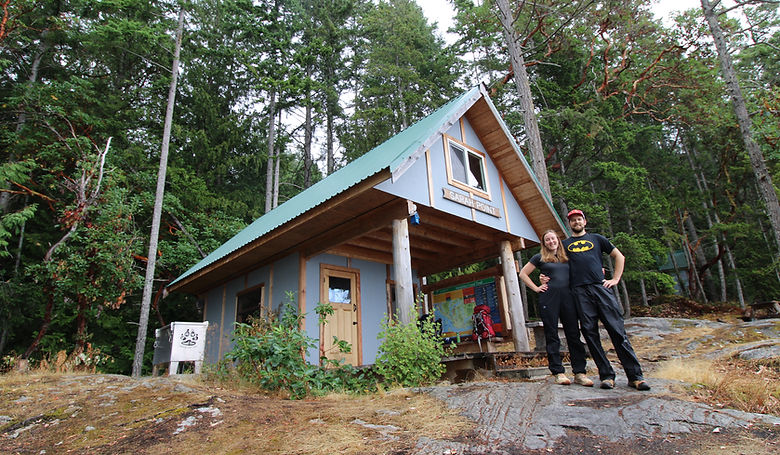
We spent about half an hour at the Sarah Point Hut organizing ourselves before setting off on the trail. After using the toilet, eating a snack, donning our rain gear, and taking a photo to commemorate the start of the journey, we finally stepped onto the trail at 11:30am.
The first 500m or so of the trail is along the coast, but then the trail turns inland after the Sarah Point Campsite and starts to climb. After only 1km, we were already dripping with sweat. The rain had stopped right as we had begun the trail and now the air was muggy, making it inefficient for our bodies to cool themselves. We stripped of our rain gear.
As we wandered through the damp forest, I took deep inhales of the wondrous petrichor. Slugs and frogs were out in numbers after the morning rain, so I found myself looking down at my feet most of the time so as not step on any little creatures. At one point, I paused and turned to ask my boyfriend, "Do you hear that?" "No", he replied. "It's so quiet in here!", I marvelled. I swear I could almost feel my serotonin levels rising like a battery being charged. My serenity was tainted only by mosquitos attacking my juicy shoulders.
We stopped at Bliss Portage Hut to use the toilet, have a snack, and for me to retrieve out of my backpack my new Dragonfly Wingman clip on dragonfly that is supposed to deter bugs. Dark clouds were looming over us now, and I tossed out the idea of staying at Bliss Portage Hut to avoid the coming rain. We had only done 8km of our planned 16km for the day, so stopping here would have a domino effect that would really mess with our itinerary for the rest of the trail; therefore, we decided to carry on, hoping to stay ahead of the storm front.
Only about 500m after Bliss Portage Hut, we reached a viewpoint over Desolation Sound. Moments ago, we he had felt deep in the woods, but now we realized how close to the coast we actually were.
At Wednesday Lake, there was a sign marking that this was the last water source for 7km, so we stopped to fill up all of our water containers. The creek that crosses the trail was dry, so we had to go off trail to access the lake instead. The sky was just beginning to sprinkle, so we put our rain gear back on and left our backpacks under tree cover. To get away from the swampy end of the lake and access cleaner water, we carefully walked along logs out into the lake. As I was filling up the first bottle, the rain picked up and was no longer just a sprinkle. I tried to work quickly, but the Sawyer Squeeze can only filter so fast. I nearly slipped into the lake walking back towards my boyfriend to trade him the full water bottle for an empty one. As we filled the next bottle, the rain turned torrential. I felt streams of water pouring down my neck inside my jacket. Thunder boomed above us, and I felt very exposed standing out in the lake. We decided to forgo filling up any more water containers and hustle our butts to Manzanita Hut with what water we had. I was already soaked through, but there was still hope to keep the contents of my backpack dry; therefore, I threw my emergency rain poncho over me and my backpack.
On the 4km trudge to Manzanita Hut, I stopped bothering trying to avoid stepping in puddles, as my feet were already squelching in my boots. I tried to keep a positive mindset, telling myself that the rest of the days on trail would be better than this one because this should be the only day of rain. At one point, the thunder sounded like it was right above us, booming so loudly I could feel it shake my body. I was terrified to be hiking in a thunderstorm, every crack of the lightning making my heart pound and my body tense. My boyfriend, on the other hand, seemed excited by the experience.
I was relieved when we finally reached the safety of Manzanita Hut. There were 7 other hikers already huddled inside, and I was surprised to find the hut so busy because we hadn't seen a single soul all day. I was very glad to discover that the clothes inside my backpack were still dry, and I promptly changed. Amongst other clotheslines criss-crossing the hut, we found space to hang our wet clothes, the line sagging under the weight of the saturated garments.
About an hour after we arrived at Manzanita Hut, the storm blew over and the rain stopped. When I went outside to clean our dinner dishes, I saw a sign down the trail saying that Sliammon Lake, our destination for tomorrow, was 24km away. I brought word to my boyfriend that we had a big day tomorrow. He expressed concern at being able to manage that distance, admitting that he had barely managed the 16km we did today and had been limping the last couple kilometres. I had no idea because he had been behind me. "What happened? Why were you limping?", I asked. He told me that the knee injury he had sustained skiing a year and a half ago was acting up. Since that time, we have done multiday hikes without issue, so neither of us anticipated this would be a problem now. I had a sinking feeling in my stomach that we might not going to be able to finish the SCT.
Before tucking into bed, my boyfriend and I whined that we were probably not going to get any sleep tonight because odds are that one of these other people in the hut will snore.
Day 2 - Manzanita Hut to Sliammon Lake
Walking Time: ~9 hours
Distance: 24 km
Elevation Gain: 839m
We woke up at 7am because one of the other hikers in the hut had an alarm that went off. When I said good morning to my boyfriend, I was met with a glare, so I took it that he had not slept well. "It's miraculous that nobody snored, hey?", I said. I shared with him that I still found it hard to sleep because the rustling of gear as people changed position seemed to echo in the loft the A-frame. His sleep had also been disturbed by the loud rustling.
We set off at 9:30am, leaving behind the group of 5 young folks who were still packing up. The first 3km of trail was downhill. When we reached the end of the descent, a sign for water pointed to the right. A few meters off trail, a small creek was trickling enough for us to fill up our water bottles. As we did, the group passed us.
Not long after, we crossed a logging road and had a short uphill section. This area was ugly, appearing to have been recently logged. The exposure did offer a nice view back over towards the Georgia Strait though.
We caught up to and passed the group, who had stopped to take a rest. We took a rest ourselves not long after when we came upon a bench with a nice view of the Okeover Inlet. When we heard the group approaching, we hit the trail again, not wanting to continue this game of leapfrog.
When we got to Malaspina Road, there was a cooler of drinking water that had been left by trail angels. We initially passed it up because we still had a decent amount from the creek this morning. I couldn't recall when the next water source was though, especially with many of the smaller sources being dry right now. We doubled back to be on the safe side. The jugs of water were ice cold! We chugged a bunch, went back for seconds, and topped off our bottles before leaving.
On the other side of Malaspina Road, the trail was pretty flat all the way to Plummer Creek, which is where we stopped for lunch. Right after crossing the bridge over the creek, there is a bench that gave us a spot to rest our legs. I didn't want to stop for long, feeling antsy that we had only done 10km in about 4 hours. We were not even halfway through the kilometres for the day and most of the elevation is at the end, so I feared we were in for a very long day. We agreed we were at least going to Appleton Creek, but would decide when we got there if we would push on to Sliammon Lake. My boyfriend joked that he could go for a nap this afternoon at Rievely Pond Hut. I tried to be encouraging that we should sleep better in our tent tonight than we did in the hut last night. My boyfriend replied, "I'm not sure about that. Remember this morning when you commented that nobody snored last night? It was actually you. You were the one snoring last night". I hung my head in shame. I've complained so many times about how rude it is when people who snore stay in shared accommodations and now I was the culprit.
After Plummer Creek, the trail stayed flat, and I was eager to crush some kilometres. This section of trail had some lovely scenic features, including a waterfall, a section of Red Alder forest, and some massive old growth fir trees.

Once we crossed Southview Road, we knew it was time for the climb we had been dreading all day. Rievely Pond Hut was only 5km away, but we had to do 300m elevation gain.
On the way, we passed the 30km marker. I wanted to take a photo to commemorate 30km on the SCT for my 30th birthday.

The climb to Rievely Pond was not as bad as I had anticipated. We stopped there for a snack and to plug my phone into the backup battery. I was desperate for a dip in the lake, so I told my boyfriend that I wanted to push on the 6km to Sliammon Lake rather than stop after 2km to stay at Appleton Creek. I tried to convince my boyfriend by telling him that there would be no more climbing, as it was all downhill to the lake. While we were discussing our plans, the French couple who had been staying at Manzanita Hut with us last night suddenly appeared. We were confused where they had come from because they had left much earlier than us this morning and we had not seen them on trail at any point today, so it made no sense that they were behind us. He asked where we were staying tonight and we told him we were aiming for Sliammon Lake. He shared that they were planning to go to Little Sliammon Lake, which is another 3km further. I commended them on such a big day.
When we approached Appleton Creek, there was a sign notifying us that a section of trail had been rerouted, adding 500m but improving safety. Desperately trying to finish this 24km day, an extra 500m was not what we wanted to hear. I stopped at Appleton Creek to use the toilet. Afterwards, I checked my phone and saw it had not been charging. I asked my boyfriend if he could figure out why and he exclaimed, "You broke it!". Somehow, the charging cable had gotten so bent that it had actually snapped the plug in. Now we had no way to use the backup battery. Luckily, we would be going to Powell River tomorrow and could buy a new charging cable, but it would be a nuisance and costly to take a taxi into town. In the meantime, I stopped tracking us on AllTrails to conserve what little battery I had left.
The last 4km to Sliammon Lake felt like 8km. My boyfriend looked utterly exhausted by this point. He said he was encouraged that he had been able to hike 24km despite his bummed knee, and that, in turn, made me feel encouraged that we might be able to finish the SCT after all!
When we finally arrived at Sliammon Lake, we had the whole camp to ourselves! I immediately dropped my backpack and changed into my bathing suit for the long-awaited swim. Jumping into the lake felt even better than I had imagined!
Before bed, we had to do a bear hang, which was a first for both of us. We surveyed this section of forest and discovered that trees with sturdy branches at the right height are few and far between. While not the ideal set up, we settled on a dead tree that had fallen at an angle.
Right as we kissed goodnight, we heard a thunderous crack. We knew our bear hang had fallen, but the question was whether the tree had snapped under the weight of our food or a bear had broken the tree trying to reach our food. We were reluctant to check in case it was the latter. Thankfully, what we found was the former. Now, in the dark, we had to find an alternative. After we did and we tucked back into our tent, we both lay awake for a while waiting to hear another crack.
Day 3 - Sliammon Lake to Powell River
Walking Time: 4h
Distance: 10km
Elevation Gain: Unsure
When I hauled my backpack up onto my shoulders, I thought that it already felt awfully heavy and today we would be adding substantially more weight when we picked up out food resupply. I was dreading the stretch we would be doing this afternoon with our loaded backpacks, but tried to encourage myself that my backpack would be getting lighter and lighter after today. We set off at 9:30am already dreaming about lunch at the Shingle Mill Pub.
My boyfriend was dawdling behind me this morning. I waited for him to catch up to inquire into how his knees were feeling. He told me they were hurting already and that now his good knee was worse than his bad knee because he had been compensating all of yesterday. I asked if he wanted to stop for a moment to take an Advil and he snapped back, "I already did and it didn't do anything". "Oh, I didn't see you open the first aid kit this morning." I replied sheepishly. He sighed and told me bluntly, "I'm not having fun." Those words gave me goosebumps. I provided the best encouragement I could, reassuring him today would be much shorter than yesterday and that a hot meal at the Shingle Mill Pub would rejuvenate him. I knew he was not convinced. We pressed on.
About 1km later, we came to a clearing up high above Sliammon Lake. I thought this would be the perfect spot for a snack, so I took a seat on a boulder and tucked into a Clif Bar. My boyfriend joined me shortly after, groaning as he sat down on a nearby boulder. With his head buried in his hands, he told me that he was not going to be able to do another 7 days of this. I had been waiting with bated breath for him to tell me that he was officially tapping out, so I had already been coming to terms with the fact that we might not finish the SCT. His voice wavered as he told me, "I don't want to be the reason that you don't finish". I realized in that moment how heavily this decision had been weighing on him and I knew that he must have been experiencing a great deal of physical pain for that to outweigh the emotional anguish of feeling as though he was letting me down. I told him, "We don't have to finish the trail, but I'm not going home". My hunger for adventure had not been satiated by these 3 days of hiking and I knew I would be depressed sitting around at home with a week off of work, so I wanted to keep adventuring somehow. We made a plan to do a road trip to Northern Vancouver Island, which I had never seen despite living on Vancouver Island almost my entire life. While I was deeply disappointed by not getting to cross the SCT off my bucket list, I was excited by the prospect of visiting San Josef Bay, as this is also on my bucket list. My boyfriend told me that I could keep going on the SCT without him, but I never seriously considered it, as I knew I would enjoy the experience much less by myself because I would be uneasy the whole time being in bear country alone.
From this point on, we hiked with a slower pace because there was no time pressure anymore.
After hiking for around 2 hours, it became clear that we were nearing civilization because we started coming across day hikers and people walking their dogs. One lady stopped to chat with us and she asked if we were going to be going up Scout Mountain or taking the alternate route that skirts the mountain. I left the decision to my boyfriend and he was feeling up to doing one last climb, so up Scout Mountain we trudged.
At what turned out to actually be a false summit, we found ourselves looking out over Sunset Park, where we have played disc golf numerous times over the years on trips to Powell River.

Shortly after, we made it to the real summit. There was a couple sitting on a bench enjoying the view. "I like your dragonfly," she commented. I had forgotten about the fake dragonfly bobbing on my shoulder and felt a bit self-conscious now that there were people around to judge me. I explained that it is supposed to function as a bug deterrent and is not just an accessory, but I'm not sure how effective it has been. The couple encouraged us that we were not far from the Shingle Mill Pub now.
The path down Scout Mountain was slow going because it was very steep, narrow, and uneven, as well as being blocked by blowdown in a couple places. I got a nasty scratch on my back from ducking under a tree and catching myself on a broken branch. I was glad when we finally reached the road because it meant we were done with that sketchy section of trail and that very soon we would be biting into a long-awaited burger.
Despite only being on trail a few days, the food at the Shingle Mill Pub still tasted exceptionally good and the beer hit hard! While we were enjoying our meal, we saw the group of young folks we had stayed with in Manzanita Hut loading their backpacks into a car. I got to thinking about how everything in life is a matter of perspective. We had done the same hike as them but left with very different feelings of the experience. We were wallowing in our failure because we had planned to do the full trail, but they were no doubt feeling elated because they had only ever set out to do this stretch of trail.
My boyfriend was having second thoughts about leaving the trail and was open to continuing if there would not be anymore 25km days because he doubted his knees could handle that. I reviewed our itinerary and saw that we did have another 25km day, as well as days that were only a bit shorter but with more elevation change. This confirmed his decision, so we called a taxi to take us back to our car.
Seeing our car made me tearful, but I blinked away the tears because I knew that me crying would make my boyfriend feel much worse about the situation. My heart was aching thinking about how we were supposed to be cheering at the sight of our car, 7 days from now, when we finished the SCT. Instead, for the first time, I was leaving a trail unfinished.