
West Coast Trail
The West Coast Trail (WCT) is a 75km point-to-point backcountry backpacking trail on the southwest coast of Vancouver Island. The trail includes both forest sections and beach sections, as well as featuring over 70 bridges, over 130 ladders, and 3 cable cars. The trail was previously called the Dominion Lifesaving Trail and was built in 1907 to facilitate the rescue of shipwreck survivors, but it became popular with hikers and is now attempted by over 6000 people per year.
Why?
My dad has hiked the entirety of the WCT 3 times and parts of the trail around a dozen times, so I grew up hearing stories of his trips. These inspired me to want to hike the trail myself. Every year for over 5 years now I have considered hiking the WCT, but have kept putting it off until the next year. You have to reserve the WCT at the beginning of January, and I never knew my schedule for the summer that far in advance. When my friend Kerry reached out to me to say that he and a couple of his friends were planning to hike the trail this summer and asked if I wanted to join them, I finally committed.
Day 1 - Gordon River to Thrasher Cove
Distance: ~6km
Time: ~5 hours
It is a 2 hour drive from Victoria to the Gordon River Orientation Centre where we needed to check in and obtain our maps and permits before catching the ferry to the southern trailhead. My dad kindly dropped us off and then we set off with heavy backpacks and big smiles.

The southern end of the trail starts with a long and nearly vertical ladder from the beach into the forest, which is a harsh way to be introduced to the trail. I'm not afraid of heights, but I would be lying if I said I didn't start feeling a little shaky as I neared the top. I wanted to adjust my backpack before we continued because it was not sitting comfortably, and I also wanted to move my bear spray to a place that was easier for me to reach. When I shoved the bear spray into a side pocket of my backpack, it deployed, gassing an innocent family that had been waiting at the top of the ladder and soaking my shirt. I sprinted down the trail away for everyone, while the family scattered into the bushes coughing and gagging. In a split second my excitement to be starting the trail was replaced by embarrassment at my blunder and pain as the bear spray began to burn my flesh. I considered turning around and trying the trail again fresh next year, but the thought of not hiking the trail was gut wrenching. Maddie doused my back with water, which provided temporary relief. Kerry reassured me that the effects would dissipate in an hour or so, so I decided to endure the unpleasantness and keep hiking.
I tried to keep my complaining to a minimum for the day, but I was in extreme discomfort. The intense burning finally faded to a warmth after about 2 hours, but it would repeatedly become aggravated. When we arrived at camp, I filed a water bottle in the creek and used that to rinse any remaining bear spray off my skin. I then, foolishly, washed my shirt in the hopes of salvaging it. I managed to get most of the stain out with an excessive amount of soap and aggressive scrubbing, but not the smell. Shortly after, my hands began to burn, even worse than my back had burned earlier. I washed them thoroughly, but the burning came back each time. I got no sleep that night because it felt as though my palms were on fire.
Day 2 - Thrasher Cove to Camper's Bay
Distance: ~8km
We opted for the beach route so that we could visit Owen Pt. It is only passable at times below 1.8m, which our tide chart said is low tide for the day and would be around 12:30. The day started with the infamous "boulder field", which was 2 hours of scrambling over large rocks. After Owen Pt. was easy walking along sandstone shelf. We stopped for lunch at the beach access before heading inland for the last part of the day. We contemplated going past Camper Creek to the next campground at Cullite Creek, but we spoke with a group who had done just that on their previous hike of the WCT and they advised doing that section on fresh legs. The 3km of inland trail had lengthy sections of boardwalk, which were a breeze. We took the cable car across Camper Creek because we were excited to give a cable car a try, but the creek was dry enough that we could have easily hoped across on rocks. Once we set up camp, Maddie and I refreshed ourselves with a brisk dip in the creek.
 |  |  |
|---|---|---|
 |  |  |
Day 3 - Camper's Bay to Walbran
Distance: ~9km
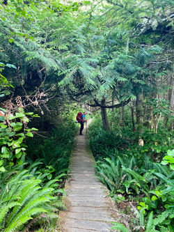
Day 3 felt a bit like an obstacle course because this section of the trail has basically all of the features that can be found along the WCT. There was a cable car, multiple series of tall steep ladders, a suspension bridge, lengthy sections of boardwalk, and deep mud puddles. We passed through what another hiker calls the "bonsai forest", which he named as such because the trees are stunted due to the high acidity of the soil in that area. I really enjoyed the varied terrain that the trail brought on day 3 because it made for interesting hiking and kept the kilometres from feeling monotonous. As we neared the campsite, I could sense a weariness amongst the group, evidenced mainly by Kerry's more frequent checks of his GPS to update us on how much further we had to go.
Walbran Creek has a large pool of fresh water, which we took advantage of to quickly wash ourselves and our clothes, as well as to enjoy a refreshing swim. Our neighbours at the campsite were a family of 5: Mark, his 2 adult children Brandon and Candice, Brandon's partner Jamie, and Candice's partner Jakob. They seemed as though they were not having a fun time because there was a lot of bickering going on amongst themselves, and poor Jamie was taping her swollen ankle.


Day 4 - Walbran Creek to Cribs Creek
Distance: ~11.5km
Day 4 was all beach walking and easy relative to the other days on the trail. We had heard conflicting reports about whether Chez Monique's was still in operation, so we kept our fingers crossed while we hiked. We were disappointed when we arrived at the site where the burger stand used to be to find that burgers were no longer on offer, but the small consolation was that we could still purchase candy bars, chips, and water as a midday pick me up.
We arrived at camp quite early and decided to spend the rest of the afternoon napping. Cribbs Creek is shallow, so a freshwater swim was unfortunately not an option that night. When we took a look at our route for the next day and checked the tide chart, I got stressed about the 2.5km shortly after departing from Cribbs Creek that are only passable at tides below 2.1m. High tide was 2.5m at 10:45am and the hourly chart said the tide would be 2.1m by 9am. We couldn't wait until after high tide to set off because day 5 was going to be a long day at 16km. Our neighbours were the same family from the night before and we strategized with them. Our groups decided we would need to get up at 6am, leave by 7:30am, and then hike fast to get from our campsite at 41.5km to past the 38.6km mark before 9am.

Day 5 - Cribs Creek to Tsusiat Falls
Distance: ~16km
My 26th birthday landed on day 5 of our hike, which was not planned and just worked out that way based on the dates we were able to reserve. In my opinion, we couldn't have planned it any better if we had tried because day 5 brought the promise of a cold beer at the crab shack.
When we got to the safe zone at 38.6km where we no longer needed to worry about tides, we felt a bit like we had been deceived by the tide guide. We had woken up early and rushed for seemingly no reason because the tide appeared plenty low enough, never threatening to block our path. We stopped for a snack and then hesitantly went inland, entering the woods in an area where there is an abundance of wildlife activity. The trail we passed through on the way to the crab shack was some of the best maintained of the entire trail, with overgrown bushes having been just recently trimmed back.
 |  |  |
|---|---|---|
 |  |
At the crab shack, we ordered our food and grabbed our drinks, and then sat down at a picnic table next to the family of 5, who had strolled in just behind us. Service was extremely slow, and we didn't get our food until close to 2 hours after ordering. While we waited, we got to chatting with the family of 5. Jakob kindly bought me another beer and the family also insisted I take a shot of Fireball from their flask.
When we started back on the trail after taking the ferry across the Nitinaht Narrows, I was definitely feeling a little tipsy. Kerry had eaten too much, so his pace was drastically slower than usual. We stuck closer together than normal because none of us were feeling in peak form after our stop a the crab shack. The last 3km or so of the day were along the beach. We passed through the hole in the wall at Tsusiat Pt when the tide was just low enough that you could get around the point if you timed your 10m run with the waves.
When we got to camp, we set up our tents by the family of 5. I indulged in a bath and swim under the Tsusiat Falls, followed by a delectable birthday dinner of KD. Candice and Jakob asked if we would like to play board games with them and we took them up on their offer. We played snakes and ladders until the sun went down.

Day 6 - Tsusiat Falls to Michigan Creek
Distance: ~13km

Day 6 started with a long series of ladders from the beach into the forest. We hiked for around 2km before reaching the cable car across Klanawa River. This was the the only cable car that we actually had to take because the river was impassable otherwise. On the other side is a campsite, where we stopped to use the facilities and have a snack. The next 2.5km was beach walking and then the trail ducked back inland for around 3.5km. There were plenty of viewpoints along the inland stretch of trail, but there was not much for us to see on this foggy day. Just before we crossed bridge 35 and popped back out onto the beach, we passed a large, fresh pile of bear scat, so we were on high alert. For the next 3km or so we had a choice of inland or beach route and, as we had for the rest of the trip, we opted for the beach route. I got a tad emotional about the fact that this was our last section of beach walking for the trail.
When we arrived at Michigan Creek, the campsite was already busy. All the people we saw looked so fresh. We figured they were all southbound hikers just beginning the trail, but most groups we spoke to had actually started at Nitinaht Narrows and were only hiking half of the trail. We set up camp, with Maddie and I choosing a sandy spot on the beach and the boys choosing a dirt spot under the shade of the trees. Shortly after setting up our tent, the wind blew it free. After retrieving my tent, I staked it into the sand again, this time adding rocks on top of each peg. Just as the family of 5 arrived at the campsite, our tent started flying down the beach and Jakob caught it. Kerry witnessed this event and advised me to put rocks over the pegs. I snapped at him, "I already tried that! Don't talk to me like I'm an idiot." I begrudgingly set up our tent for a third time, this time adding rocks inside our tent in each of the corners. We had a feast that night, cooking up all of our remaining food except for what we needed for breakfast. Jakob told us he had a card game to show us and pulled out a European card deck, which I had never seen before. He taught us a game from his home country, which was really fun once we finally got a handle on the rules! When we called it a night, Jakob kindly gave the deck to Maddie and told her to teach the game to others. Since we were getting an early start, we would not see the family of 5 in the morning, so we said our goodbyes before bed.
Day 7 - Michigan Creek to Pachena Bay
Distance: ~12km
Time: ~3 hours
When we had checked in at Gordon River to start the WCT, we had been told by the Parks Canada staff member that the last day of our hike is by far the easiest section and would probably take around 4 hours. We were catching the bus back to Victoria, which only runs once a day at 1:15pm, so we had to make it to Pachena Bay by 1pm. We wanted to give ourselves a buffer, so we opted to wake up at 6am to leave by 7:30am, which would give us over 5 hours to do 12km. When we reached the 7km mark by 9am, we knew we could slow down. Kerry sped off down the trail by himself, while the rest of us took it easy, savouring the last kilometres of the trail. We took the inland route for the last 1km, which turned out to be a mistake because it was all ladders. When we got to the end, Kerry handed each of us a WCT patch. It was only around 10:30am, so we had hours to kill before the bus would arrive. We bet on whether the family of 5 would show up, and I guessed they would arrive before noon. Sure enough, at 11:45am, we saw the family of 5 emerge from the woods! We sat around playing cards and eating snacks until we boarded the bus. After a 6.5 hour ride, we were back in civilization. We said our final goodbye to the family of 5 as they rushed off in hopes of catching the final ferry to Vancouver.
